Community Modeling and Analysis System
SPATIAL ALLOCATOR
Generate spatial data for emission, meteorology, and air quality modeling
The Spatial Allocator (SA) is a set of tools that helps users manipulate and generate data files related to emissions and air quality modeling. The tools perform functions similar to Geographic Information Systems (GIS), but are provided to the modeling community free of charge. In addition, the tools are designed to support some of the unique aspects of the file formats used for Community Multiscale Air Quality (CMAQ), Sparse Matrix Operator Kernel Emissions (SMOKE), and Weather Research and Forecasting (WRF) modeling.
The SA is licensed as open-source Linux software that was developed with funding from the U.S. EPA. The SA uses GIS industry standard ESRI shapefiles, image files supported by GDAL, netCDF files and plain text data files as input and output data.
Features:
Vector Tools
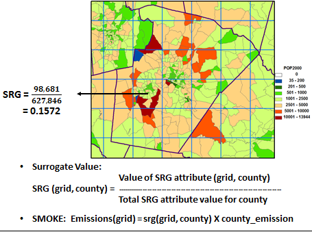
The Vector Tools allow you to develop individual spatial surrogates, to change the map projection of Shapefiles, to remap spatial data from one spatial domain to another (e.g. counties to grids, fine grids to coarse grids), and to perform other types of spatial manipulation without using a GIS.
Raster Tools
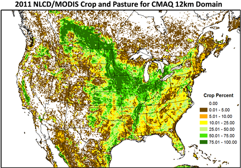
The Raster Tools allow you to process land use data, satellite data, and agricultural fertilizer application data for meteorological and air quality modeling, particularly within the WRF/CMAQ modeling systems.
Surrogate Tools
The Surrogate Tools allow you to manage the creation of large sets of spatial surrogates and also supports merging and gapfilling of surrogates.
Updates in this Release:
- Includes the new Postgres Surrogate Tool, for generating surrogates using a PostgreSQL database with the PostGIS extension. Quick Start Guide
Latest Version: SA-TOOLS version 4.4
DOWNLOAD | DOCUMENTATION
Training
Hands-on Spatial Allocator training is currently being developed by the CMAS Center. We anticipate that this training will become available to the community in the near future and will be offered at the CMAS Center training facility in Chapel Hill, NC.Support
Online Resources
- NLCD/MODIS Processing for WRF Modeling. Talk at the CMAS 2012 conference (slides)
- Spatial Allocator Raster Poster. poster at the CMAS 2010 conference (slides)
- Development of Fertilizer Modeling system for CMAQ bi-directional NH3 model. Talk at the NATO/SPS ITM 2009 meeting (slides)
- Spatial Allocator Raster Presentation. Talk at the CMAS 2009 conference (slides)
- NLCD/MODIS Data Processing Tools and Projection Issues. Talk at the CMAS 2008 conference (slides)
Previous Documentation
System Requirements
| O/S | Linux |
| Software | All needed Spatial Allocator components are contained in the installation package. |
Partners
History of SA-TOOLS
- SA 4.4 (06/30/2019) - Added Postgres Surrogate Tool
- SA 4.3.2 (09/20/2018) - Updated release
- SA 4.3.1 (04/26/2017) - Updated release
- SA 4.3 (05/31/2016) - Updated release
- SA 4.3 (02/09/2016) - Updated release
- SA 4.3 (09/30/2015) - Updated release
- SA 4.3 (05/31/2014) - Updated release
- SA 4.1 (10/25/2013) - Updated release
SA was first developed for surrogate computation and vector data processing to support some of the unique aspects of the file formats used for CMAQ and SMOKE. Those tools are specifically used to process shapefiles (or vector data) and are now stored under the Vector Tools. Later on, we developed Java-based Surrogate Tools which allow users to compute multiple surrogates and perform QA on the computed surrogates. During the last few years, we have been focused on the development of the Raster Tools which are used to process land use data and satellite images for WRF and CMAQ modeling. The tools which integrate the WRF/CMAQ with the EPIC for the FEST-C system were also developed under the Raster Tools. The development of the SA system is mainly supported by the U.S. EPA and the development of satellite image processing tools is supported by NASA ROSE projects.
Community Modeling and Analysis System (CMAS)
General inquiries about the CMAS Center and questions about the web site should be directed to cmas@unc.edu