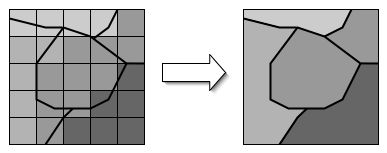
For on-road mobile sources when using MOBILE6, the gridded meteorology data must be converted to county-specific data to facilitate the very large number of MOBILE6 runs that will ultimately be performed. This is done in SMOKE by computing a weighted-average value for each county, with the weighting calculation being done using the VMT data. Each weighting factor is the VMT in the grid cell divided by the total county VMT, resulting in a factor for each grid cell that intersects the county. These factors are stored in the “ungridding” matrix created during spatial allocation by the Grdmat program when running on-road mobile sources in SMOKE. Figure 2.25, “Representation of ungridding” shows how the spatially varied meteorology data at left would be averaged using the averaging weights to calculate a value for each county in the domain. The handling of meteorology data for MOBILE6 by SMOKE is further described in Section 2.16, “On-road mobile-source processing with MOBILE6”.