- 2.12.2.1. Spatial allocation of area/nonpoint, nonroad mobile, and on-road mobile nonlink sources
- 2.12.2.2. Spatial allocation of area-to-point sources
- 2.12.2.3. Spatial allocation of pregridded sources
- 2.12.2.4. Spatial allocation of on-road mobile link sources
- 2.12.2.5. Spatial allocation of point sources
SMOKE takes a different approach to assigning sources to grid cells for each SMOKE source category and some special cases. In the following subsections, we describe the concepts of spatial allocation of (1) area/nonpoint, nonroad, mobile, and on-road mobile nonlink sources; (2) area-to-point sources; (3) pregridded area sources, (4) on-road mobile link sources, and (5) point sources.
The area/nonpoint, nonroad mobile, and on-road mobile nonlink sources all have emissions in the inventory with county-total values. To spatially allocate these emissions, factors must be assigned to each source to distribute the county-total emissions across the grid cells that intersect the county. This is accomplished using a cross-referencing approach that assigns a spatial surrogate to each source in the inventory.
The spatial surrogates files (AGPRO or MGPRO) contain factors for allocating emissions from a county-total to a gridded value, and there are usually many sets of factors available for each county. The data in this file are used to estimate the spatial distribution of county-total emissions inside the county. These sets of factors are calculated from other data that are available at a finer resolution than the county data, such as census tracks. Examples of commonly available surrogates are population, housing, urban area, rural area, agriculture, water, railroads, major highways, airports, ports, and forest. To ensure correct emissions processing, it is essential that all counties within the inventory and domain be included in the spatial surrogates file. If any counties inside the domain are left out of the file, then SMOKE will not be able to detect this; instead, it will act as though the county is outside of the domain and drop the emissions.
The general case of cross-referencing and profiles was described in Section 2.4, “Cross-referencing and profiles”. During spatial allocation with the Grdmat program, the spatial cross-reference file (AGREF or MGREF) assigns spatial surrogates for area/nonpoint, nonroad mobile, and on-road mobile nonlink sources. The spatial cross-reference file associates SCCs with a spatial surrogate code, which is an arbitrary positive integer code that also appears in the spatial surrogates file along with the spatial surrogate data. It is important to ensure (if possible) that the spatial surrogate codes assigned to each SCC are actually available in the surrogate file for all counties in the inventory with that SCC. For example, if the water surrogate is assigned to motorboat sources in a given county, the spatial surrogate file should have values for the water surrogate in that county. If this is not the case, SMOKE will be forced to use a “fallback” surrogate, set with the SMK_DEFAULT_SRGID environment variable setting, which assigns a surrogate that is defined for every county in the domain (population, for example). This fallback approach prevents the emissions for that county and source category from being dropped from the emissions processing. Grdmat produces warnings in the log file whenever the fallback surrogate is used. If the fallback surrogate also causes the emissions to go to zero, an additional warning that indicates the emissions are being dropped is also written to the Grdmat log file.
Because the surrogate codes are arbitrarily assigned, you need to make sure that the spatial cross-reference is developed in conjunction with the spatial surrogates so that the surrogate codes used in each are consistent. It is not generally wise to develop surrogates without a cross-reference, unless the surrogate codes used in the surrogates file are set to the same values that are in a spatial cross-reference file that is already available.
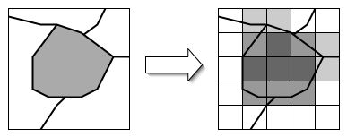
Figure 2.23, “Spatial allocation of county-total emissions” illustrates spatial allocation of all county-based emissions sources. The box at the left represents a grid with a single county, shaded in gray to represent an emissions value in that county. The arrow represents the spatial allocation steps. The box at right shows that all grid cells that intersect the county have emissions contributed by the county. Cells that intersect more of the county are shown in darker colors, simulating the effect of using area surrogates. The darker cells could also represent cells in which a large city causes the population surrogate to concentrate the emissions in those cells, while the surrounding regions within the county have lower emissions.
In some cases, the inventory import processing (by the Smkinven program) will have assigned point locations to some of the county-based inventory sources such as airports. Spatial allocation for these sources ignores the assigned surrogate, sets the surrogate assignment to 0, and uses the point-source locations and assigned fractions to determine the cells and associated magnitudes of the emissions from the county-total source.
When pregridded data are provided to SMOKE, the spatial allocation step must still be run. In this case, Grdmat just maps the pregridded emissions to the correct cells and outputs a simple gridding matrix that is used in later processing steps to maintain the pregridded nature of the inventory.
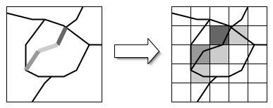
On-road mobile link sources are straight line segments within a county that have emissions and/or VMT data associated with them as well as the latitudes and longitudes of the starting and ending positions of the link. SMOKE determines the fraction of each link within each grid cell, and then assigns the emissions or VMT from the link to those grid cells that the link intersects, by weighting the emissions according to the length of the link within a grid cell divided by the total length of the link.
As shown in Figure 2.24, “Spatial allocation of on-road mobile link sources”, three link sources in the left-hand diagram are joined at their ends to represent a road cutting through the county. As shown in the figure, link sources do not bisect county boundaries (new link sources would be used to continue the road into an adjoining county). The three portions of the link have different VMT values, as represented by the three different shades of gray that highlight the link. The arrow represents the spatial allocation step. In the right-hand diagram, the cells that intersect the link sources are shaded, with darker shading used in cells in which the link intersects the cell more and the link has higher VMT.
Spatial allocation of point sources in Grdmat is very straightforward. The Grdmat program simply determines which cell the lat-lon coordinates are in and assigns all emissions from that source to a single grid cell. Except for (1) plume-in-grid sources for all models and (2) elevated sources for UAM-based models (both addressed in Section 2.15, “Elevated-source processing”, this means that the AQMs do not have information about where in the grid cell the point source is located.