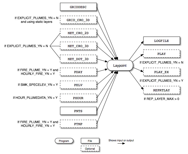
Figure 4.6, “Laypoint input and output files” shows the input and output files for the Laypoint program. The input files include the grid description file (GRIDDESC) and meteorology files created by the meteorology preprocessor (GRID_CRO_3D, MET_CRO_2D, MET_CRO_3D, and MET_DOT_3D). If elevated sources have been selected, Laypoint uses the the elevated point source identification file output from Elevpoint (PELV). Hourly plume data can be read from the PHOUR hourly inventory file and annual inventory data is read from the PNTS file, both output from Smkinven. When processing fire sources, the PDAY file created by Smkinven and the PTMP file created by Temporal may be used.
Laypoint outputs a log file (LOGFILE), hourly plume rise layer fractions for all sources (PLAY) or optionally only for explicit sources (PLAY_EX), and a report file REPRTLAY if reporting is turned on using the REP_LAYER_MAX setting.
| File Name | Format | Description |
|---|---|---|
GRIDDESC |
ASCII | Description of the modeling grid |
GRID_CRO_3D (optional)
|
I/O API NetCDF | Meteorology file produced by the meteorology preprocessor; only needed if using static layer information |
MET_CRO_2D |
I/O API NetCDF | Meteorology file produced by the meteorology preprocessor |
MET_CRO_3D |
I/O API NetCDF | Meteorology file produced by the meteorology preprocessor |
MET_DOT_3D |
I/O API NetCDF | Meteorology file produced by the meteorology preprocessor |
PDAY (optional)
|
I/O API NetCDF | Daily point-source inventory file produced by Smkinven |
PELV (optional)
|
ASCII | Elevated point source identification file produced by Elevpoint |
PHOUR (optional)
|
I/O API NetCDF | Hourly point-source inventory file produced by Smkinven |
PNTS |
SMOKE map | Intermediate inventory file produced by Smkinven |
PTMP |
I/O API NetCDF | Hourly emissions file produced by Temporal |
-
EXPLICIT_PLUMES_YN: [default: N]Indicates whether only explicit plume rise sources should be calculated.
-
Y: Process only explicit plume rise sources; automatically sets
HOUR_PLUMEDATA_YNto Y -
N: Process all sources
-
-
FIRE_AREA: [default: 0.0]Sets daily area burned in acres/day; only used when
FIRE_PLUME_YNis set to Y andHOURLY_FIRE_YNis set to N. -
FIRE_BOTTOM_LAYER_1_YN: [default: N]Enforcing fire emissions vertical allocation starting from modeling layer 1 to Brigg's fire plume height top layer.
-
FIRE_HFLUX: [default: 0.0]Sets hourly heat flux value in BTU/hr; only used when
FIRE_PLUME_YNis set to Y andHOURLY_FIRE_YNis set to N. -
FIRE_PLUME_YN: [default: N]Indicates if fire-specific plume rise calculations should be used.
-
Y: Use fire-specific plume rise calculations for all sources
-
N: Use traditional plume rise calculations based on stack parameters for all sources
-
-
HOUR_PLUMEDATA_YN: [default: N]Indicates whether hourly plume rise data should be used.
-
Y: Use hourly data; requires
PHOURfile -
N: Do not use hourly data
-
-
HOURLY_FIRE_YN: [default: N]Indicates if hourly fire data should be used; only checked when
FIRE_PLUME_YNis set to Y.-
Y: Read hourly heat flux from
PTMPfile and daily area burned fromPDAYfile -
N: Get heat flux and area burned from environment variables
FIRE_AREAandFIRE_HFLUX
-
-
IOAPI_ISPH: See description in Section 4.3.3.2, “Input Environment Variables” -
PLUME_GTEMP_NAME: [default: TEMP2]Sets ground temperature variable name from meteorology file for plume rise calcuation.
-
REP_LAYER_MAX: [default: -1]Layer number for reporting high plume rise; reporting is turned off if set to less than 1.
-
SMK_EMLAYS: [default: -1]Number of emissions layers; must be at least 4 otherwise program will not run.
-
SMK_SOURCE: See description in Section 4.2.3.2, “Input Environment Variables”. -
SMK_SPECELEV_YN: [default: N]Defines whether the Elevpoint output file
PELVwill be used to set elevated sources.-
Y: Use the
PELVfile to set elevated sources during run -
N: Let Laypoint plume rise calculation determine whether or not sources are elevated
-
-
USE_EDMS_DATA_YN: [default: N]Process EDMS aviation source elevation height as its plume rise and distributes the emissions into the layer where it belongs to.
-
Y: Skip plume rise calculation and distribute EDMS aviation emissions into the layer where it belongs to using its elevation height.
-
N: Do not process EDMS aviation sources
-
-
VELOC_RECALC: [default: N]Determines whether velocity should be recalculated based on hourly flow rates and stack diameter.
-
Y: Recalculate velocity for hourly data
-
N: Use velocity values from hourly inventory file
-
-
VERTICAL_SPREAD: [default: 0]Sets the vertical spread method for determining the bottom and top heights of each plume.
-
0: Use the default Turner approach where plume thickness equals the amount of plume rise
-
1: Compute vertical spread using ambient temperature data
-
| File Name | Format | Description |
|---|---|---|
LOGFILE |
ASCII | Log generated from executing Laypoint |
PLAY |
I/O API NetCDF | Hourly plume rise layer fractions by source |
PLAY_EX |
I/O API NetCDF | Hourly plume rise layer fractions for explicit sources |
REPRTLAY |
ASCII | Report file for plumes exceeding specified layer |
