The spatial processing operation, or gridding, combines the grid specification for the air-quality modeling domain with source locations from the SMOKE inventory file. The resulting gridding matrix is a sparse matrix that describes in which grid cells the emissions for each source occur within the modeling domain. The gridding matrix is applied to the inventory emissions to transform source-based inventory emissions to gridded emissions.
The SMOKE Grdmat program creates the gridding matrix for area, mobile, and point sources. The gridding step is different depending on the type of source being processed.
-
For area sources, county-total emissions are spread among the cells intersecting the county through the use of gridding surrogates.
-
For mobile sources, the data can be provided by county (as area sources are), or the data can be provided as line sources (“links”). County-based mobile emissions are apportioned with gridding surrogates, preferably with surrogates based on the different road types for which the mobile emissions are provided. The line-source emissions are apportioned depending on the length of the link in each cell. For on-road mobile sources, Grdmat also computes an ungridding matrix, which is needed for processing using MOBILE6.
-
For point sources, emissions are apportioned to the grid cell intersecting the point.
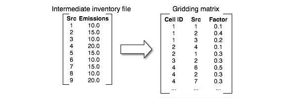
As shown in Figure 2.22, “Relationship between inventory and gridding matrix”, the gridding matrix contains the SMOKE source IDs that intersect each grid cell, and the source-to-cell factors for each. The gridding matrix is a sparse matrix because each source intersects only a small number of cells relative to the total number of cells in the domain, and the storage format shown in the figure reflects a sparse storage format. In the example in Figure 2.22, “Relationship between inventory and gridding matrix”, source 1 intersects cells 1 and 2, with 10% of the emissions in cell 1 and 30% of the emissions in cell 2. The remainder of the source’s emissions (60%) are either outside the grid or in other cells not shown in this example. Source 2 is completely inside the domain; 40% of its emissions are in cell 1, 30% are in cell 2, and 30% are in cell 4. If this were a point-source speciation matrix, there would be only one cell associated with each source because each point source exists in only one cell.
Note that the gridding matrix depends only upon the source locations, the grid definition, and in some cases gridding surrogates and cross-references. It is therefore independent of the other steps of emissions processing.
Spatial processing addresses the following issues during emissions processing:
-
Defining the gridded region to output from SMOKE
-
Assigning sources to grid cells
-
Computing an ungridding matrix for on-road mobile sources
-
Creating the spatial allocation intermediate files
The grid for which the spatial allocation step outputs the gridding and ungridding matrices depends upon the IOAPI_GRIDNAME_1 environment variable setting and the GRIDDESC input file. The file contains all of the settings needed by the I/O API to define each grid (together, these settings are
called a grid definition), and it contains many such grid definitions. The IOAPI_GRIDNAME_1 setting selects the specific grid to use during a specific run, and it must match the grid name provided in the GRIDDESC file. The settings used by the I/O API to define a grid are documented as part of the I/O API web site.
There is another file format, called the G_GRIDPATH file, that can be provided to Grdmat instead of the GRIDDESC file. However, the G_GRIDPATH format allows only one grid per file. It is included as an acceptable input to SMOKE to allow SMOKE to be backwardly compatible
with previous versions. All new users are advised to use a single GRIDDESC file to store all of their modeling grids, instead of using multiple G_GRIDDPATH files, one for each grid. The IOAPI_GRIDNAME_1 setting is not used by Grdmat when the G_GRIDPATH format is used.
The gridded region selected at run time does not need to cover all of the counties in the inventory. If the gridded region is smaller than the inventory, this processing step will still include the counties or parts of counties that do not overlap the grid. This allows users who are performing emissions processing using nested grids to import the inventory once and apply gridding matrices for each grid to the same inventory, creating gridded emissions for all nested grids without having to adjust the inventory files. The downside of this approach is that SMOKE does not give a warning if a county that is in the inventory is not in the spatial surrogates, or if a lat-lon coordinate is not inside the grid. It assumes that these sources are intended to be dropped and proceeds without comment. Thus, you must ensure that your surrogate files contain the counties in your inventory that are inside the grid and that your lat-lon coordinates for point and link sources are correct.