1. Spatial Allocator Raster Tools
The Spatial Allocator (SA) Raster Tools contain programs for processing land use data, satellite data, and agricultural fertilizer application data for meteorological and air quality modeling, particularly within the Weather Research and Forecasting (WRF) and Community Multiscale Air Quality (CMAQ) modeling systems.
Users who have difficulties running the tools with the compiled libraries contained within the downloaded system should do the following:
1) delete installed open-source library directories under the ./src/libs directory
2) download new source packages and install them under the ./libs directory
3) compile downloaded packages and install them under {package_path}/local, following the src/libs/README file
4) modify paths in ./bin/sa_setup.csh and ./src/raster/Makefile
5) in ./src/raster, do the following:
· make clean
· make
· make install
All sample script files for the SA Raster Tools are stored in the raster_scripts directory.
The SA Raster Tools are described in detail in the following sections of this document:
- Section 2: Domain Description in SA Raster Tools
- Section 3: Land Cover Data Processing Tools
- Section 4: Satellite Cloud and Aerosol Product Processing Tools
- Section 5: Agricultural Fertilizer Modeling Tools
- Section 6: Other Tools and Utilities
2. Domain Description in SA Raster Tools
The SA Raster Tools define the modeling domain using the following environment variables:
· GRID_PROJ – defines the domain grid projection using the PROJ4 projection description format (http://www.remotesensing.org/geotiff/proj_list/). The following sample projection descriptions are used to match the projections in WRF:
§ Lambert Conformal Conic: "+proj=lcc +a=6370000.0 +b=6370000.0 +lat_1=33 +lat_2=45 +lat_0=40 +lon_0=-97"
§ Polar stereographic: "+proj=stere +a=6370000.0 +b=6370000.0 +lat_ts=33 +lat_0=90 +lon_0=-97 +k_0=1.0"
§ Mercator: "+proj=merc +a=6370000.0 +b=6370000.0 +lat_ts=33 +lon_0=0"
§ Geographic: "+proj=latlong +a=6370000.0 +b=6370000.0"
· GRID_ROWS – number of the rows of domain grid cells
· GRID_COLUMNS – number of the columns of domain grid cells
· GRID_XCELLSIZE – grid cell size in x direction
· GRID_YCELLSIZE – grid cell size in y direction
· GRID_XMIN – minimum x of the domain (lower left corner of the domain)
· GRID_YMIN – minimum y of the domain (lower left corner of the domain)
· GRID_NAME – Name of the domain, which is required by some of the tools
For WRF simulations, GRID_XMIN and GRID_YMIN can be computed using the first point longitude and latitude from the global attributes corner_lons and corner_lats in the domain’s WRF geogrid output file. For instance, to compute a WRF LCC domain with the geogrid output file attributes
:corner_lats = 20.85681f, 52.1644f, 50.63151f, 19.88695f, 20.84302f...
:corner_lons = -121.4918f, -135.7477f, -53.21942f, -69.02478f, -121.5451f…
users would use the cs2cs utility in the PROJ4 library directly at the command line (after installing the SA system):
>cs2cs +proj=latlong +a=6370000.0 +b=6370000.0 +to +proj=lcc +a=6370000.0 +b=6370000.0 +lat_1=33 +lat_2=45 +lat_0=40 +lon_0=-97
-121.4918 20.85681
-2622003.85 -1793999.28 0.00
Minimum x and y for the domain would be computed as follows:
GRID_XMIN = -2622003.85 - GRID_XCELLSIZE / 2
GRID_YMIN = -1793999.28 - GRID_YCELLSIZE / 2
3. Land Cover Data Processing Tools
There are two land cover processing tools in the SA Raster Tools: NLCD and MODIS land cover generation tool (Section 3.1), and Biogenic Emissions Landuse Database, version 4 (BELD4) land cover generation tool (Section 3.2).
3.1 NLCD and MODIS Land Cover Generation
The computeGridLandUse.exe tool is used to generate land cover data for the recently upgraded WRF/CMAQ Pleim-Xiu Land Surface Model (PX LSM), by directly using downloaded 2001 V2 or 2006 NLCD land cover data and the NASA MODIS land cover products MCD12Q1 or MOD12Q1. This tool generates 40 land cover classes (20 from MODIS and 20 from NLCD) instead of the 50 classes generated by the previous land cover processing tool.
This tool requires the following data sets:
- NLCD land cover, canopy, and imperviousness data – can be obtained from http://www.mrlc.gov/nlcd2006.php.
- MODIS land cover data sets – can be obtained from http://ladsweb.nascom.nasa.gov/ data/search.html. The tool can process MCD12Q1 data at 500 m from Combined Terra and Aqua MODIS, or can process MOD12Q1 data at 1 km from Terra MODIS.
- List of land cover data sets to be processed – a sample file for CMAQ 12-km domain 2006 modeling, nlcd_modis_files_2006.txt, is provided in the data directory. This file has to have fixed header formats.
To run the computeGridLandUse tool, users can use the following sample script file, which has all of the required environment variables:
NLCD_MODIS_processor.csh
There are two output files generated from the NLCD/MODIS processing tool—one ASCII file and one NetCDF file:
· The ASCII file contains the imperviousness, canopy, and land cover percent variables (if the user set all land cover data to “YES” when running the script file) for each grid cell, in comma-separated-values (CSV) format.
· The NetCDF file contains imperviousness, canopy, and land cover fraction variables plus land/water mask and other variables that are similar to those in the WRF GEOGRID land cover output files. The land cover percent variable contains the 40 classes in Table 1.
Table
1. NLCD/MODIS output land cover classes from the computeGridLandUse
tool
|
Array Index |
MODIS Class IGBP (Type 1) |
Class Name |
Array Index |
NLCD Class |
Class Name |
|
1 |
1
|
Evergreen Needleleaf forest |
21 |
11
|
Open Water |
|
2 |
2
|
Evergreen Broadleaf forest |
22 |
12 |
Perennial Ice/Snow |
|
3 |
3 |
Deciduous Needleleaf forest |
23 |
21 |
Developed -
Open Space |
|
4 |
4 |
Deciduous
Broadleaf forest |
24 |
22 |
Developed -
Low Intensity |
|
5 |
5 |
Mixed
forest |
25 |
23 |
Developed -
Medium Intensity |
|
6 |
6 |
Closed shrublands |
26 |
24 |
Developed
High Intensity |
|
7 |
7 |
Open shrublands |
27 |
31 |
|
|
8 |
8 |
Woody
savannas |
28 |
41 |
Deciduous |
|
9 |
9 |
Savannas |
29 |
42 |
|
|
10 |
10 |
Grasslands |
30 |
43 |
Mixed |
|
11 |
11 |
Permanent
wetlands |
31 |
51 |
Dwarf Scrub |
|
12 |
12 |
Croplands |
32 |
52 |
Shrub/Scrub |
|
13 |
13 |
Urban and
built-up |
33 |
71 |
Grassland/Herbaceous |
|
14 |
14 |
Cropland/Natural
vegetation mosaic |
34 |
72 |
Sedge/Herbaceous |
|
15 |
15 |
Snow and
ice |
35 |
73 |
Lichens |
|
16 |
16 |
Barren or
sparsely vegetated |
36 |
74 |
Moss |
|
17 |
0 |
Water |
37 |
81 |
Pasture/Hay |
|
18 |
18
|
Reserved (e.g., Unclassified) |
38 |
82
|
Cultivated Crops |
|
19 |
19
|
Reserved (e.g., Fill Value ) |
39 |
90
|
Woody Wetlands |
|
20 |
20
|
Reserved |
40 |
95
|
Emergent Herbaceous Wetlands |
3.2 BELD4 Land Cover Generation
The BELD4 data with land cover, tree, and crop percentages can be computed using the computeGridLandUse_beld4.exe tool with directly downloaded USGS NLCD data sets, NASA MODIS land cover (MCD12Q1 or MOD12Q1) data tiles, and tree and crop fractions at the county level. The following sample script file contains all of the required environment variables for using the tool:
landuseTool_WRFCMAQ_BELD4.csh
This tool requires the following data sets:
· Downloaded USGS NLCD data sets, including land cover, imperviousness, and canopy – can be obtained from the NLCD web site: http://www.mrlc.gov/nlcd2006.php.
· MODIS land cover tiles (MCD12Q1 or MOD12Q1) – can be obtained from the NASA MODIS land products site: http://modis-land.gsfc.nasa.gov/landcover.html.
· List of land cover data sets to be processed – a sample file (nlcd_modis_files_2006.txt) is provided in the data directory for 2006 BELD4 data processing. Users need to modify it based on their downloaded data sets. The file has to be fixed format with the data set headers included.
· BELD3 FIA tree fraction table at county level – provided in the data directory: beld3-fia.dat.
· NASS crop fraction tables at county level – provided in the data directory: nass2001_beld4_ag.dat for the 2001 NASS; nass2006_beld4_ag.dat for the 2006 NASS.
· Canada crop fraction table at Census-division level – provided in the data directory: can01_beld4_ag.dat for the 2001 Census of Agriculture; can06_beld4_ag.dat for the 2006 Census of Agriculture.
· List of land cover, tree, and crop classes for the BELD4 tool – provided in the data directory: beld4_class_names_40classes.txt.
· U.S. county shapefile – provided in the data directory: county_pophu02_48st.shp.
· Canada Census-division shapefiles – provided in the data directory: can2001_cd_sel.shp for the 2001 Census; can2006_cd_sel.shp for the 2006 Census.
Two output files are generated from the tool—one ASCII file and one NetCDF file:
- The ASCII file contains the imperviousness, canopy, and land cover fraction variables (if the user set all land cover data to “YES” when running the script file) for each grid cell, in CSV format.
- The NetCDF file contains imperviousness, canopy, land cover, tree, and crop percentage variables as well as land/water mask and other variables that are similar to those in the WRF GEOGRID land cover output files.
The land cover data generated by applying this tool are used in CMAQ bidirectional ammonia flux modeling and are to be used in CMAQ biogenic, land surface, and dry deposition modeling . The land cover percent array in the output contains 20 land cover classes from the NLCD and 20 MODIS IGBP land cover classes (see Table 1).
The tree percentage variable in the NetCDF output file contains 194 BELD4 tree classes (Table 2). The crop percentage variable contains 42 crops (Table 3).
Table
2. BELD4 tree classes
|
Index |
Variable |
Index |
Variable |
Index |
Variable |
Index |
Variable |
Index |
Variable |
|
1 |
Acacia |
40 |
Hackberry |
79 |
Oak_bur |
118 |
Paulownia |
157 |
Pine_whitebark |
|
2 |
Ailanthus |
41 |
Hawthorn |
80 |
Oak_CA_black |
119 |
Pawpaw |
158 |
Pine_Wwhite |
|
3 |
Alder |
42 |
Hemlock |
81 |
Oak_CA_live |
120 |
Persimmon |
159 |
Pine_yellow |
|
4 |
Apple |
43 |
Hickory |
82 |
Oak_CA_white |
121 |
Pine_Apache |
160 |
Populus |
|
5 |
Ash |
44 |
Holly_American |
83 |
Oak_canyon_live |
122 |
Pine_Austrian |
161 |
Prunus |
|
6 |
Basswood |
45 |
Hornbeam |
84 |
Oak_chestnut |
123 |
Pine_AZ |
162 |
Redbay |
|
7 |
Beech |
46 |
Incense_cedar |
85 |
Oak_chinkapin |
124 |
Pine_Bishop |
163 |
Robinia_locust |
|
8 |
Birch |
47 |
Juniper |
86 |
Oak_delta_post |
125 |
Pine_blackjack |
164 |
Sassafras |
|
9 |
Bumelia_gum |
48 |
KY_coffeetree |
87 |
Oak_Durand |
126 |
Pine_brstlcone |
165 |
Sequoia |
|
10 |
Cajeput |
49 |
Larch |
88 |
Oak_Emery |
127 |
Pine_chihuahua |
166 |
Serviceberry |
|
11 |
Califor-laurel |
50 |
Loblolly_bay |
89 |
Oak_Engelmann |
128 |
Pine_Coulter |
167 |
Silverbell |
|
12 |
Cascara-buckthor |
51 |
Madrone |
90 |
Oak_evergreen_sp |
129 |
Pine_digger |
168 |
Smoketree |
|
13 |
Castanea |
52 |
Magnolia |
91 |
Oak_Gambel |
130 |
Pine_Ewhite |
169 |
Soapberry_westrn |
|
14 |
Catalpa |
53 |
Mahogany |
92 |
Oak_interio_live |
131 |
Pine_foxtail |
170 |
Sourwood |
|
15 |
Cedar_chamaecyp |
54 |
Maple_bigleaf |
93 |
Oak_laurel |
132 |
Pine_jack |
171 |
Sparkleberry |
|
16 |
Cedar_thuja |
55 |
Maple_bigtooth |
94 |
Oak_live |
133 |
Pine_Jeffrey |
172 |
Spruce_black |
|
17 |
Chestnut_buckeye |
56 |
Maple_black |
95 |
Oak_Mexicanblue |
134 |
Pine_knobcone |
173 |
Spruce_blue |
|
18 |
Chinaberry |
57 |
Maple_boxelder |
96 |
Oak_Northrn_pin |
135 |
Pine_limber |
174 |
Spruce_Brewer |
|
19 |
Cypress_cupress |
58 |
Maple_FL |
97 |
Oak_Northrn_red |
136 |
Pine_loblolly |
175 |
Spruce_Englemann |
|
20 |
Cypress_taxodium |
59 |
Maple_mtn |
98 |
Oak_nuttall |
137 |
Pine_lodgepole |
176 |
Spruce_Norway |
|
21 |
Dogwood |
60 |
Maple_Norway |
99 |
Oak_OR_white |
138 |
Pine_longleaf |
177 |
Spruce_red |
|
22 |
Douglas_fir |
61 |
Maple_red |
100 |
Oak_overcup |
139 |
Pine_Monterey |
178 |
Spruce_Sitka |
|
23 |
East_hophornbean |
62 |
Maple_RkyMtn |
101 |
Oak_pin |
140 |
Pine_pinyon |
179 |
Spruce_spp |
|
24 |
Elder |
63 |
Maple_silver |
102 |
Oak_post |
141 |
Pine_pinyon_brdr |
180 |
Spruce_white |
|
25 |
Elm |
64 |
Maple_spp |
103 |
Oak_scarlet |
142 |
Pine_pinyon_cmn |
181 |
Sweetgum |
|
26 |
Eucalyptus |
65 |
Maple_striped |
104 |
Oak_scrub |
143 |
Pine_pitch |
182 |
Sycamore |
|
27 |
Fir_balsam |
66 |
Maple_sugar |
105 |
Oak_shingle |
144 |
Pine_pond |
183 |
Tallowtree-chins |
|
28 |
Fir_CA_red |
67 |
Mesquite |
106 |
Oak_Shumrd_red |
145 |
Pine_ponderosa |
184 |
Tamarix |
|
29 |
Fir_corkbark |
68 |
Misc-hardwoods |
107 |
Oak_silverleaf |
146 |
Pine_red |
185 |
Tanoak |
|
30 |
Fir_fraser |
69 |
Mixed_conifer_sp |
108 |
Oak_Southrn_red |
147 |
Pine_sand |
186 |
Torreya |
|
31 |
Fir_grand |
70 |
Mountain_ash |
109 |
Oak_spp |
148 |
Pine_scotch |
187 |
Tung-oil-tree |
|
32 |
Fir_noble |
71 |
Mulberry |
110 |
Oak_swamp_cnut |
149 |
Pine_shortleaf |
188 |
Unknown_tree |
|
33 |
Fir_Pacf_silver |
72 |
Nyssa |
111 |
Oak_swamp_red |
150 |
Pine_slash |
189 |
Walnut |
|
34 |
Fir_SantaLucia |
73 |
Oak_AZ_white |
112 |
Oak_swamp_white |
151 |
Pine_spruce |
190 |
Water-elm |
|
35 |
Fir_Shasta_red |
74 |
Oak_bear |
113 |
Oak_turkey |
152 |
Pine_sugar |
191 |
Willow |
|
36 |
Fir_spp |
75 |
Oak_black |
114 |
Oak_water |
153 |
Pine_Swwhite |
192 |
Yellow_poplar |
|
37 |
Fir_subalpine |
76 |
Oak_blackjack |
115 |
Oak_white |
154 |
Pine_tablemtn |
193 |
Yellowwood |
|
38 |
Fir_white |
77 |
Oak_blue |
116 |
Oak_willow |
155 |
Pine_VA |
194 |
Yucca_Mojave |
|
39 |
Gleditsia_locust |
78 |
Oak_bluejack |
117 |
Osage-orange |
156 |
Pine_Washoe |
|
|
Table
3. BELD4 crop classes
|
Index |
Variable |
Index |
Variable |
Index |
Variable |
|
1 |
Hay |
15 |
Cotton |
29 |
SorghumSilage |
|
2 |
Hay_ir |
16 |
Cotton_ir |
30 |
SorghumSilage_ir |
|
3 |
Alfalfa |
17 |
Oats |
31 |
Soybeans |
|
4 |
Alfalfa_ir |
18 |
Oats_ir |
32 |
Soybeans_ir |
|
5 |
Other_Grass |
19 |
Peanuts |
33 |
Wheat_Spring |
|
6 |
Other_Grass_ir |
20 |
Peanuts_ir |
34 |
Wheat_Spring_ir |
|
7 |
Barley |
21 |
Potatoes |
35 |
Wheat_Winter |
|
8 |
Barley_ir |
22 |
Potatoes_ir |
36 |
Wheat_Winter_ir |
|
9 |
BeansEdible |
23 |
Rice |
37 |
Other_Crop |
|
10 |
BeansEdible_ir |
24 |
Rice_ir |
38 |
Other_Crop_ir |
|
11 |
CornGrain |
25 |
Rye |
39 |
Canola |
|
12 |
CornGrain_ir |
26 |
Rye_ir |
40 |
Canola_ir |
|
13 |
CornSilage |
27 |
SorghumGrain |
41 |
Beans |
|
14 |
CornSilage_ir |
28 |
SorghumGrain_ir |
42 |
Beans_ir |
3.3 Current and Future Development for the Land Cover Data Processing Tools
We will use NLCD 2011 data sets when they become available. In addition, in the future we plan to use USDA’s NLCD Cropland Data Layer (CDL) data instead of NASS crop fractions at the county level for the BELD4 data tool. This will allow us to use USDA crop spatial coverage NLCD data instead of crop census data in computing crop fractions within each grid cell.
4. Satellite Cloud and Aerosol Product Processing Tools
4.1 GOES Cloud Product Processing Tool
The GOES data tool processes the GOES data downloaded from the Earth System Science Center (ESSC) at the University of Alabama in Huntsville. The GOES data web site is http://satdas.nsstc.nasa.gov/.
Downloaded GOES data need to be stored under subdirectories named using this format: gp_YYYYMMDD. The ./util/goes_untar.pl utility can be used to unzip downloaded GOES data (daily tar files) into the daily directories required by the tool.
Users can follow the sample script file with all required environment variables:
allocateGOES2WRFGrids.csh
The current tool contains the following three programs:
· correctGOESHeader.exe – to correct GOES data position shifting by redefining a new Earth radius and new image extent. The program converts GOES data in Grib (i.e., *.grb) format to files in ERDAS Imagine (i.e., *.img) format with corrections.
· computeGridGOES.exe – to regrid corrected Imagine-format GOES data to a defined grid domain.
· toDataAssimilationFMT.exe – to convert the gridded NetCDF file into a format suitable for WRF assimilation.
We plan to update the tool when new GOES data spatial specifications become available.
Notes: When running the GOES cloud product processing tool, GDAL will generate the following messages:
· Warning: Inside GRIB2Inventory, Message # 2
· ERROR: Ran out of file reading SECT0
These messages do not indicate any errors in regridding and so can be ignored.
4.2 MODIS Level 2 Cloud/Aerosol Products Tool
The MODIS Level 2 (swath) cloud and aerosol products tool processes MODIS L2 cloud or aerosol products for a defined grid domain. MODIS data in HDF4 format can be downloaded from the NASA LAADS web site: http://ladsweb.nascom.nasa.gov/data/search.html.
Cloud product variables contain 5-km and 1-km data. To use this regridding tool, users have to download the following cloud data and Level 1 Geolocation 1-km data into the input directory:
· MOD06_L2 and MOD03 (Level 1 Geolocation 1-km ) for Terra, or
· MYD06_L2 and MYD03 (Level 1 Geolocation 1-km ) for Aqua
The following download options can be selected during the downloading process:
MODIS Cloud:
· Select Level 2 products and select L2 Cloud products
· Select time: “your download time period”
· Collection 5
· Select Latitude/Longitude with area longitude and latitude extent
· Coverage options: select day, night, and both (all)
· Select all other defaults and click search
· Display all files
· Download all files into one directory
MODIS Geolocation 1-km:
· Select Level 1 products and select 03 Geolocation - 1km
· Select time: “same as cloud products”
· Collection 5
· Select Latitude/Longitude with the above geographic extent
· Coverage options: select day, night, and both (all)
· Display all files
· Download all files into the MODIS Cloud file directory
MODIS aerosol products contain variable data at 10-km resolution (nadir). Users have to download MOD04 for Terra or MYD04 for Aqua into the input data directory. The following download options can be selected when downloading Terra aerosol products:
· Select Terra MODIS
· MODIS Aerosol products
· Select Level 2 products and select L2 aerosol product
· Select time: “your download time period”
· Collection 5
· Select Latitude/Longitude with area longitude and latitude extent
· Coverage options: select day, night, and both (all)
· Select all other defaults and click search
· Display all files
· Download all files into one directory
Downloading Aqua aerosol products has the similar options. The tool generates one NetCDF file for the defined domain.
Users can modify the following sample script file provided for regridding:
allocateMODISL2CloudVars2Grids.csh
4.3 OMI Level 2 Product Tool
The OMI Level 2 products (swath) tool is used to regrid OMI L2 aerosol and NO2 products for a defined grid domain. The input data can be downloaded from the NASA mirador site: http://mirador.gsfc.nasa.gov/cgi-bin/mirador/presentNavigation.pl?tree=project&project=OMI
The downloaded data are in HDF5 format and should be stored in one directory, which is defined in the following sample script file:
allocateOMIL2vars2Grids.csh
4.4 OMI L2G and L3 Product Tools
The OMI L2G and L3 product tools process the following OMI products:
· OMI L3 aerosol products (OMAEROe) in HDF4
· OMI NO2 L2G products (OMNO2G) in HDF4
· OMI NO2 L3 products (NO2TropCS30) in HDF5
The data can be downloaded from the NASA Giovanni web site: http://gdata1.sci.gsfc.nasa.gov/daac-bin/G3/gui.cgi?instance_id=omi
OMI product information can be viewed from http://disc.sci.gsfc.nasa.gov/giovanni/additional/ users-manual/G3_manual_Chapter_10_OMIL2G.shtml#what_l2g and from ftp://aurapar2u.ecs .nasa.gov/data/s4pa//Aura_OMI_Level2/OMAERUV.003/doc/README.OMI_DUG.pdf
The following sample script can be modified for regridding:
allocateOMIvar2Grids.csh
5. Agricultural Fertilizer Modeling Tools
Four tools have been developed for use when performing Environmental Policy Integrated Climate (EPIC) modeling; these tools generate gridded agricultural fertilizer data to be used in CMAQ bidirectional ammonia flux modeling. The four tools can be called from the Fertilizer Emission Scenario Tool for CMAQ (FEST-C) Interface (http://www.cmascenter.org/fest-c/) based on user input information. They can be run by script files with defined environment variables at the command line. These tools, discussed in Sections 5.1 through 5.4, are the EPIC site information generation tool, the MCIP/CMAQ-to-EPIC tool, the EPIC-to-CMAQ tool, and the EPIC yearly extraction tool.
5.1 EPIC Site Information Generation Tool
This tool generates two CSV data files that are needed to create EPIC site databases for a user-defined domain:
· EPICSites_Info.csv – contains GRIDID, XLONG, YLAT, ELEVATION, SLOPE_P, HUC8, REG10, STFIPS, CNTYFIPS, GRASS, CROPS, CROP_P, COUNTRY, and COUNTRY-PROVINCE items.
· EPICSites_Crop.csv – contains GRIDID, 42 crop acreages, COUNTRY, and HUC8 items.
The tool processes the following input spatial data files modified specifically for the tool:
· BELD4 file for the domain (beld4_cmaq12km_2006.nc)
· U.S. county shapefiles (co99_d00_conus_cmaq_epic.shp)
· North American State political boundary shapefile (na_bnd_camq_epic.shp)
· U.S. 8-digit HUC shapefile (conus_hucs_8_cmaq.shp)
· Elevation image file (na_dem_epic.img)
· Slope image file (na_slope_epic.img)
Those processed spatial data sets can be obtained from the CMAS. Users can follow the sample script file with all required environment variables to run the tool from the command line window:
generateEPICSiteData.csh
5.2 MCIP/CMAQ-to-EPIC Tool
This tool generates EPIC daily weather and nitrogen deposition data files from MCIP meteorology and CMAQ nitrogen deposition files for EPIC modeling sites. The input MCIP and CMAQ data are stored in two directories defined by the environment variables DATA_DIR and DATA_DIR_CMAQ.
MCIP output files have to be named as METCRO2D*{date} (e.g., METCRO2D_020725). The date format can be in one of the following formats:
YYYYMMDD or YYMMDD or YYYYDDD or YYDDD
CMAQ dry and wet deposition files have to be named as *DRYDEP*{date} and *WETDEP*{date} (e.g., CCTM_N4a_06emisv2soa_12km_wrf.DRYDEP.20020630 and CCTM_N4a_06emisv2soa_12km_wrf.WETDEP1.20020630). The date can be in any of the formats listed above.
Deposition for EPIC modeling can take the following three inputs:
1) CMAQ dry and wet deposition file directory
2) Zero – assume zero nitrogen deposition
3) Default – assume nitrogen mix ratio of 0.8 ppm for wet default deposition computation
The input site location file defined by the environment variable EPIC_SITE_FILE has to be a comma-separated file, with the first three items being site ID, longitude, and latitude.
The tool generates three outputs:
· dailyWETH directory containing EPIC daily weather and nitrogen deposition files named as “grid ID”.dly (e.g., 96.dly). The daily file contains the 14 variables listed in Table 6.
· NetCDF file with daily weather and nitrogen deposition data for all EPIC sites.
· EPICW2YR.2YR, to be used in EPIC modeling.
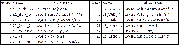
Table 6. EPIC
daily weather and nitrogen deposition variables
|
Index |
Variable |
Index |
Variable |
|
1 |
Year |
8 |
Daily Average Relative Humidity |
|
2 |
Month |
9 |
Daily Average 10m Windspeed (m s^-1) |
|
3 |
Day |
10 |
Daily Total
Wet Oxidized N (g/ha) |
|
4 |
Daily Total
Radiation (MJ m^02) |
11 |
Daily Total
Wet Reduced N (g/ha) |
|
5 |
Daily Maximum 2m Temperature (C) |
12 |
Daily Total Dry Oxidized N (g/ha) |
|
6 |
Daily minimum 2m temperature (C) |
13 |
Daily Total Dry Reduced N (g/ha) |
|
7 |
Daily Total Precipitation (mm) |
14 |
Daily Total Wet Organic N (g/ha) |
Users can follow the sample script file with required environment variables to run the tool from the command line window:
generateEPICsiteDailyWeatherNdep.csh
5.3 EPIC-to-CMAQ Tool
This tool processes merged daily output from EPIC simulations for the 42 crops defined for the BELD4 tool output. It generates two types of outputs in NetCDF format for CMAQ bidirectional ammonia modeling:
· soil output file
· EPIC daily output files
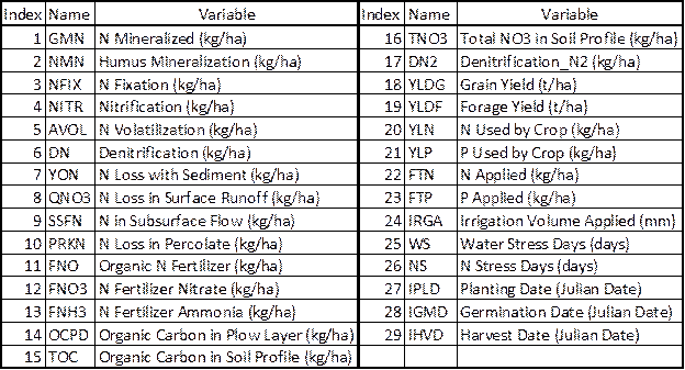
The 13 variables contained in the soil output file are listed in Table 7.
Table 7. EPIC
for CMAQ soil output variables
EPIC daily output files for CMAQ contain the 59 variables listed in Table 8.
Table 8. EPIC
for CMAQ daily output variables

The following sample script file can be modified and run at the command line:
epic2CMAQ.csh
5.4 EPIC Yearly Extraction Tool
We developed this tool primarily for performing quality assurance (QA) for EPIC runs. For EPIC spin-up runs, it extracts the last-five-years average EPIC values. For EPIC application runs, it extracts application-year EPIC variables. The tool outputs one NetCDF file with the 29 variables listed in Table 9.
Table 9. EPIC
yearly extraction output variables
Users can modify the sample script file with defined environment variables in the raster tool script directory:
epicYearlyAverage4QA.csh
6. Other Tools and Utilities
6.1 Domain Grid Shapefile Generation Tool
Users can apply the domain grid shapefile generation tool to generate a polygon shapefile for a defined grid domain with the GRIDID attribute. The GRIDID attribute has values ranging from 1 for the lower left grid cell to the maximum number of cells for the upper right grid cell. The following sample script file can be modified for domain shapefile generation:
generateGridShapefile.csh
6.2 Other Utilities
The following utility programs are stored in the util directory:
· goes_untar.pl – used to untar downloaded GOES data into the format required for the GOES processing tool.
· updateWRFinput_landuse.R – used to update the wrfinput file using generated land use data from the 2006 NLCD and MODIS Land Cover Generation tool (see Section 3.1). The updated wrfinput file can be used in WRF simulations with the updated PX LSM, using the 40 classes of NLCD/MODIS land cover data shown in Table 1.
7. Acknowledgments
The SA Raster Tools were developed with support from multiple projects:
· Work assignments from the U.S. EPA under Contract No. EP-W-09-023, “Operation of the Center for Community Air Quality Modeling and Analysis (CMAS)”
· NASA Research Opportunities in Space and Earth Sciences (ROSES) projects awarded to (1) the Institute for the Environment at the University of North Carolina at Chapel Hill with contract number NNX08AL28G and (2) the National Space Science and Technology Center at the University of Alabama in Huntsville.