NOTE: these example codes will probably need to be adapted for use with your data files. They were written for specific data files being used for testing purposes, and were NOT originally intended to be cleanly written examples of how to easily convert generic gridded data data into PAVE format. However, they are being included here with the hope that you may find them useful.
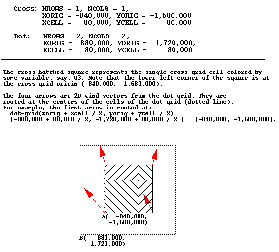
One sometimes confusing concept is the precise meaning of the XORIG, YORIG, XCELL, and YCELL parameters in an IO/API data file. Below is an image of an example of using these parameters with two different data files that need to be co-registered within a PAVE plot. Note that units are in meters.
Most geographically oriented UAM-IV input and output files are directly readable by PAVE. These include DIFFBREAK, REGIONTOP, TEMPERATURE, WIND, AIRQUALITY, BOUNDARY, TOPCONC, EMISSIONS, PTSOURCE, AVERAGE, and INSTANT.
Some of the UAM-V input and output files are compatible with the UAM-IV file formats. These files are readily visualized by PAVE because it can obtain all the information it needs from inside the files (i.e. they are "self-describing"). The files in this category are: EMISSIONS, PTSOURCE, BOUNDARY, AIRQUALITY, and the coarse grid AVERAGE and INSTANT files.
However, many UAM-V files have new formats that are not self-describing. PAVE needs additional information in order to read these files, such as the kind of data in the file, the number of rows, columns, and layers in the data, the geographic region covered, etc. The file types that fall into this category are wind, temperature, cloud, water vapor, rain, vertical diffusion, height, fine grid average, and fine grid instant.
In order to display a file of one of these latter types with PAVE, a UAM-V "metafile" must be used. A metafile is an ASCII file that contains the additional information PAVE needs to read and correctly interpret the data. To visualize data in a file that needs a metafile, select the metafile from the PAVE file browser, instead of the file that contains the data. A description of the contents of UAM-V metafiles follows.
The very first line of the metafile MUST be the following:
#! UAMV DESCRIPTION FILE
If PAVE does not find the above string, the file is considered to be of unknown type and an error is returned.
Several keywords must be present in the metafile. Each keyword should be on a separate line and followed by a value. Blank lines are permitted. The following keywords are required (and are listed in the recommended order):
UAMV_FILE
UAMV_TYPE
NCOLS
NROWS
LEVELS
XORG
YORG
DX or DLON
DY or DLAT
UTM_ZONE (for UTM-based domains only)
FINE_GRID  (for UAM-V output files only - not for input meteorology files)
TITLE
Keyword Descriptions
UAMV_FILE - the name of the file that contains the actual data to be displayed by PAVE. It can be either a full or a relative pathname to the current working directory.
UAMV_TYPE - the type of data in the UAMV_FILE. Valid choices are: Wind, Temp, Cloud, H2O, Rain, Vdif, Height, FineGridAverage, FineGridInstant
NCOLS - number of horizontal columns in the grid
NROWS - number of horizontal rows in the grid
LEVELS - number of vertical layers in the grid
XORG - the x-coordinate of the lower left corner of the grid, in km for UTM-based grids and degrees for latitude-longitude grids
YORG - the y-coordinate of the lower left corner of the grid, in km for UTM-based grids and degrees for latitude-longitude grids
DX - size of the horizontal cell in the x-direction for UTM-based grids (km)
DLON - size of the horizontal cell in x-direction for lat-lon grids (degrees)
DY - size of the horizontal cell in y-direction for UTM-based grids (km)
DLAT - size of the horizontal cell in y-direction for lat-lon grids (degrees)
FINE_GRID - logical variable. Possible values: 0 and 1. If the value is 1, the file represents data on a fine grid, otherwise it is on a coarse grid. For meteorological input files, this value should be set to one only if there is a layer of cells outside the domain specified by { XORG, YORG, NROWS, NCOLS, DX, and DY]}.
TITLE - A title for tile plots. Spaces are allowed.
Example of a UAM-V temperature metafile on the OTAG coarse grid:
#! UAMV DESCRIPTION FILE
UAMV_FILE /home/user/tmpr.cc.20jul93.ld.rams1
UAMV_TYPE  Temp
NCOLS      64
NROWS      63
LEVELS      5
XORG       -99.0
YORG       26.0
DLON       0.5
DLAT       0.3333333
FINE_GRID  0
TITLE      Coarse Grid Temperature: July 20, 1993
Example of a UAM-V fine grid average metafile on the OTAG fine grid:
#! UAMV DESCRIPTION FILE
UAMV_FILE /home/trayanov/testpave/avrg.ff.20jul93-93.mc.93basA1
UAMV_TYPE  FineGridAverage
NCOLS      137
NROWS      110
LEVELS     7
XORG       -92.0
YORG       32.0
DLON       0.16666667
DLAT       0.11111111
FINE_GRID  1
TITLE      Base Case Fine Grid Average
Example of a UAM-V temperature file on a UTM-based grid:
#! UAMV DESCRIPTION FILE
UAMV_FILE /metdata/uamv.t.jun26-28.16km.8.v4
UAMV_TYPE  Temp
NCOLS      35
NROWS      50
LEVELS     8
XORG       200.0
YORG       4400.0
DX         16.0
DY         16.0
UTM_ZONE   16
FINE_GRID  0
TITLE      Coarse Grid Temperature File
Creating metafiles with scripts
It is relatively straightforward to use a script to create metafiles. Examples of scripts that do this follow. However, the specifics (such as parsing file names to determine file type) depend on the particular application. The two examples given below are for the OTAG project. Note that these are hypertext links which are only available if you are reading this document using a Web browser.
Script to create OTAG input metafiles
Script to create OTAG output metafiles
The above scripts are provided with your PAVE installation. They are called make_in_metas and make_out_metas and are located in the scripts/ subdirectory of the top level directory where PAVE is installed. Before using them, be sure to edit the upper portion of the scripts to match your episode and directory structure.
Viewing multiple sequential files as one dataset using chain files
Data from multiple files can be concatenated and displayed as if they were from a single file. This is useful if you wish to animate over sequential data that is stored in multiple files. In order to do this you need to supply a "chain file" - an ASCII file that contains a list of the data files to be concatenated.
The first line of a chain file must be
#! LIST_OF_CHAINED_FILES
If this is not found, PAVE will not recognize that the file is a chain file. A list of full path names to the individual files to be concatenated should follow this line with one filename per line. Note that no blank lines or comment lines are permitted and the files MUST be in the order in which you wish the data to be displayed. The individual files can be one of the following types: netCDF, UAM-IV or UAM-V (regular or meta files).
A script is provided with PAVE to simplify the creation of chain files. The script will currently work only in cases where the files to be chained reside in a single directory. To create a chain file, cd to the directory that contains the files you wish to chain, and type
chain_files name_of_chain_file list_of_files_to_chainFor example:
chain_files avrg.cc.20-30jul93-93.mc.basB avrg.cc.*
Limitations: The current version of PAVE does not check the files for consistency (i.e. whether they are of the same type, whether the grid is the same in all the files, or whether the files are listed in the proper sequential order).
Here is an example of a chain file:
#! LIST_OF_CHAINED_FILES
/home/trayanov/testpave/rain.cc.20jul93.ai.meta
/home/trayanov/testpave/rain.cc.21jul93.ai.meta
/home/trayanov/testpave/rain.cc.22jul93.ai.meta
Next Chapter: Using formulas